NBM Dive Site Resource
I-7 Research Wreck
Kiska Island, Alaska, United States
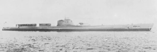
Japanese submarine I-7 lies at Twin Rocks near Kiska Island. A 2018 archaeological team documented it by ROV and SCUBA; no public dive access is verified.
Save this dive site to your free member profile.
Featured Hero Photograph
Aquatic life at this dive site
What divers may encounter
Three reviewed connections are featured here. Sightings vary by season, conditions, and chance, so they are never guaranteed.
Aquatic life research in progress
NBM is reviewing a likely local species for this position.
Aquatic life research in progress
NBM is reviewing a likely local species for this position.
Aquatic life research in progress
NBM is reviewing a likely local species for this position.
Site media
Photographs
Three views rotate from the published gallery on each visit.
Contributor media
Dive videos
Three featured video positions are reserved on every profile.Published reference location
Location map
The marker shows the public coordinates associated with this profile. Confirm current access, moorings, and departure details before the dive.Map data © OpenStreetMap contributors
Recent field observations
Diver-reported temperatures
Automatically checked observations from dives during the past 14 days. Three reports are visible at a time; scroll for more.A report that passes the automatic checks will appear here with the dive date, diver’s display name, and temperatures at each depth.
Reports are automatically checked for plausible dates, depths, and temperatures. They are observations, not forecasts; confirm conditions before diving.
Why divers know this place
Highlights
Documented WWII submarine wreck and 2018 underwater archaeological survey.
Shipwreck-only module
The wreck
This section appears only on shipwreck records and brings the vessel, its loss, present condition, access, and responsible wreck-diving considerations into one place.
- Vessel type
- Imperial Japanese Navy cruiser submarine
- Year sunk
- 1943
Before you arrive
Access notes
Remote historic site in Kiska waters. The map is approximate and is not a dive waypoint. No public charter or access permission is verified.
Plan within your training
Conditions and hazards
Remote Aleutian conditions, cold water, severe weather, protected historic site, and possible wartime hazards. Research access requires appropriate permissions.
Independent resource notice
This record is a starting point for independent verification. Access, closures, moorings, weather, currents, depth, visibility, operator availability, and site conditions can change without notice. Confirm current information with the responsible operator, property owner, managing authority, or another qualified local source before planning or attempting a dive.